Summary
A map can reveal a pattern and still fail to preserve a decision.
Spatial analysis begins with source data, canonical parcels and features, scores, and prepared layers. But the organization does not act on a color ramp. It acts on a choice: this geography, based on this evidence and vintage, should move into another workflow for review.
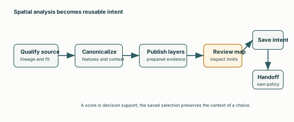
We designed geo around that handoff. The map is where a person explores prepared evidence. The saved selection is where the interpretation becomes durable. A downstream domain then applies its own policies before anything happens. The viewport, query, and screenshot remain useful context, but none is the decision itself.
That distinction turns spatial analysis from an attractive endpoint into coordination infrastructure.
Operational Tension
Spatial inputs arrive with the ordinary mess of external evidence. A source may lack stable identity, consistent geography, safe update behavior, or lineage. A parcel may be geocoded with uncertainty. An aggregate score may be useful at one grain and misleading when read as a recommendation about a single property. Straight-line proximity may hide the road network that actually constrains travel.
If every downstream system interprets raw spatial data independently, the organization gets several maps and no shared memory of what they meant. If geo turns a score directly into a marketing or territory action, it inherits policy it cannot own: suppression, delivery review, capacity, and other operating constraints.
The binding problem is not visualization. It is translating evidence about place into a bounded intent that another team or system can use without losing context or authority.
Decision: Publish Evidence, Save Intent, Hand Off Policy
The workflow separates discovery, evidence preparation, human interpretation, and downstream policy. Source discovery profiles and scores a candidate before it becomes a durable pipeline dependency. Canonical parcel and prospect data provide a typed basis for features. Geocoding, spatial indexing, and travel-time context make spatial evidence comparable. Compute-oriented jobs publish prepared score layers and safe map exports instead of rebuilding heavy analysis inside a request.
The map is a review surface for those prepared layers. An operator can inspect aggregate patterns, filters, score context, freshness, and warnings. What survives is a saved selection: chosen scope, vintage, membership, source metric or score family, and safe summary context. It preserves intent without treating a raw SQL query or a transient viewport as institutional memory.
The handoff stays narrow. Marketing can turn a selection into an audience draft and then apply its own preview, suppression, materialization, review, delivery, and attribution policies. Geo does not create audience members merely because a score exists. Marketing does not need to reconstruct the spatial method to understand the selection. Each domain owns the judgment it is equipped to make.
Failure And Repair Posture
Failures keep the responsibility of the layer that produced them. Source expansion can be deferred or rejected when identity coverage, compatible geography, refresh safety, or explainable fields are insufficient. That is a useful decision, not a connectivity error to conceal. Persisting the reason keeps a weak source from becoming a silent dependency.
A stale publication belongs to the data-product path, with lineage and freshness context. An unclear pattern belongs to operator review, not automatic action. An invalid saved selection surfaces a constraint rather than producing a misleading audience. Raw identifiers and sensitive source fields stay out of safe map exports; convenience at the review surface does not expand authority to expose the underlying record.
Repair is therefore specific: refresh the source, correct canonicalization or scoring, revise the selection, or complete downstream review. Evidence stays assembled so the operator does not have to infer whether an odd map came from a failed network job, stale features, or marketing policy.
Tradeoff
This is heavier than a dashboard query. It needs source qualification, rebuildable data products, compute jobs, explicit publication, a review surface, and saved-selection state. Refusing to treat a score as a command can slow exploration and demands clear explanations of grain, freshness, and limits.
In return, a spatial observation becomes reusable operational intent. A saved selection can cross a conversation, review, and downstream workflow without losing the evidence shape and vintage behind it. Data products can improve while the record of what was decided remains legible. A screenshot cannot do that work.
Limits
This proves that spatial evidence can be carried into an operating workflow without making the score itself authoritative. It does not prove demand, travel time, capacity, or customer behavior. Coverage, source quality, and match quality still constrain interpretation, and not every business question should be spatialized. This public account omits specific locations, source names, records, coverage figures, and score values.
Transferable Lesson
Separate evidence from intent, then separate intent from downstream policy. Publish prepared data that can be explained. Let a person save a bounded choice with its context. Require the consuming domain to apply its own controls. The map then becomes the beginning of coordinated work instead of a polished dead end.